ARVI (AirVision) is a service that was born from the desire to “support safe flight operations with clear visibility” by utilizing ARVI when airline operators are operating their flights. The “3D ARVI” service, which is now in operation, specializes in weather phenomena that have a significant impact on flight operations, and by rendering these phenomena in 3D, it is easy to intuitively grasp and understand where to avoid, making it ideal for briefing operations and other such tasks.
■ Three features of 3DARVI
*Visualization of weather in three dimensions
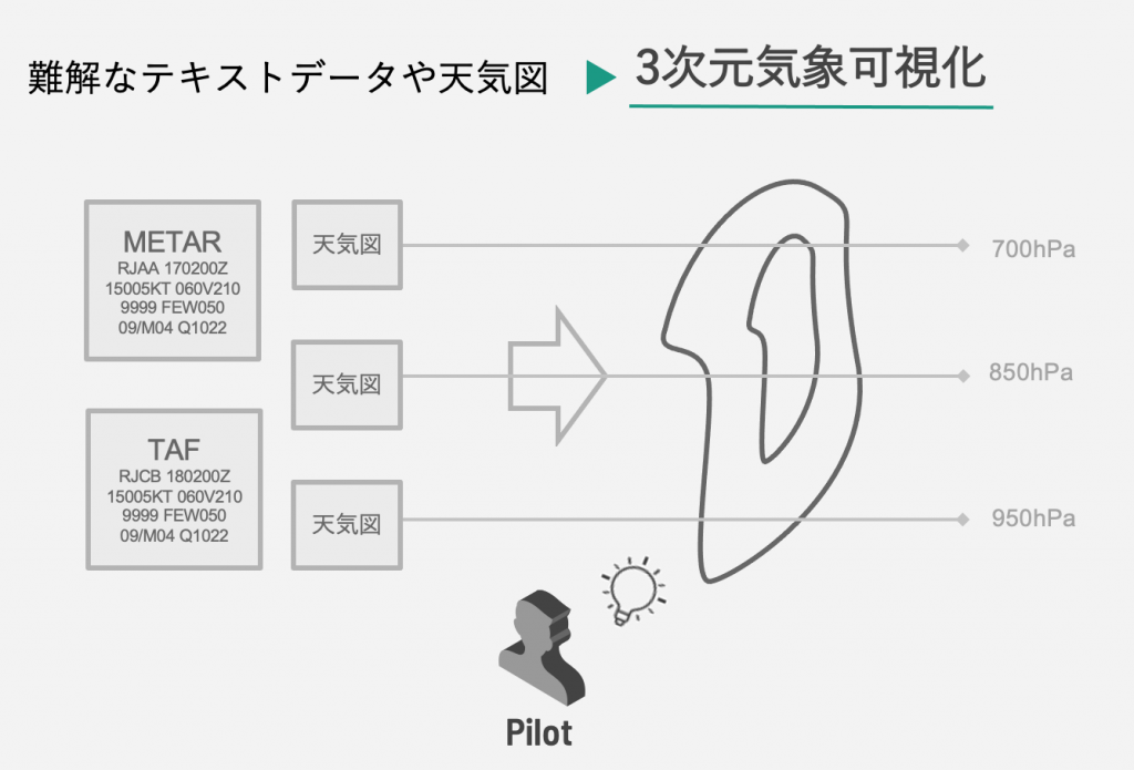
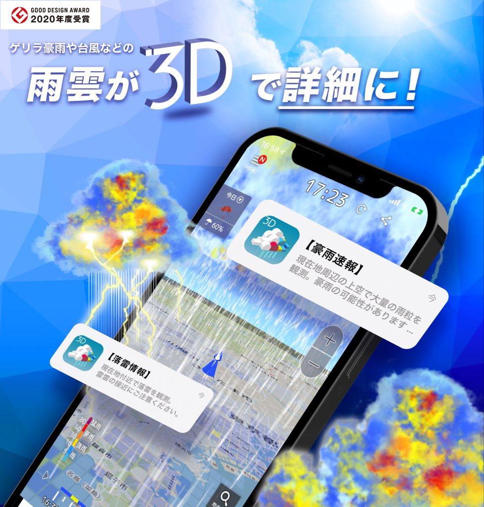
Visualize weather conditions that affect aircraft operations, such as rain, wind, clouds, temperature, lightning, and turbulence, using 3D rendering to achieve safer and more efficient operations. Difficult text data and weather maps are visualized with 3D (three-dimensional) rendering. The process of “checking and visualizing in the mind” based on the experience of those involved in flight operations is no longer necessary, and simply “checking” an easy-to-understand screen leads to quick decision-making and judgments. Translated with www.DeepL.com/Translator (free version)
*Improvement of operational efficiency
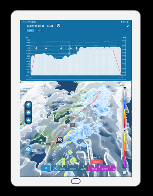
3D ARVI is “portable information”. Now you can carry the latest detailed aviation weather information with you, which until now could only be obtained by going to the office. You can check the information you need whenever and wherever you want to know it. This system greatly reduces the time-consuming work of preparing materials for briefings and contributes to more efficient business operations.
*3D rendering of induced lightning
Lightning strikes, which can damage an aircraft, are to be avoided at all costs, and 3D ARVI visualizes the danger zone in three dimensions based on JAXA’s algorithm for predicting lightning-induced cloud formations when an aircraft is approaching. A quick glance at the screen is all it takes to detect and avoid weather conditions that may cause lightning strikes to the aircraft in advance.

■ Contributing to the future of aviation meteorology with our accumulated know-how and cutting-edge technology and research
The weather information application “3DARVI” is a fusion of All Nippon Airways’ (ANA) operational know-how in aviation weather, MTI’s 3D rendering technology, and the world’s first aircraft lightning strike prediction (induced lightning) information developed by the National Aerospace Laboratory of Japan (JAXA), making it a fusion of advanced 3D rendering technology. MTI has the following development experience in 3D weather visualization technology.
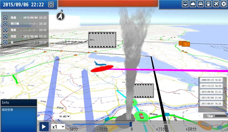
*Tornado monitoring system
Commissioned by the Japan Meteorological Agency’s Meteorological Research Institute, we developed a product to display forecast information up to 10 minutes ahead for railroad operators based on tornado and other wind gust detection information.
*3D Rain Cloud Watch
The 3D rendering is based on highly accurate observation data from the world’s most advanced weather observation radar, the Phased Array Weather Radar. The system can detect signs of guerrilla rainstorms, which used to be extremely difficult to predict, and notify users of the application in advance.
■ Toward the Next Generation of Aviation Weather (from Planning)
MTI’s expertise in 3D weather visualization, cultivated through the provision of the aviation weather service ARVI and the operation of the 3D Rain Cloud Watch, has been highly evaluated by All Nippon Airways (ANA), which has decided to proceed with joint development of a “next-generation aviation weather application”.
The purpose of aviation weather is to create flight plans for safe flight operations and to ensure the safety of aircraft and airports, which is different from the purpose of general weather and is very specific and specialized. Although our technology for three-dimensional visualization of weather information was highly evaluated, we had to go through a trial-and-error process to display this aviation weather information in a way that would lead to safe flight operations and that would also be beautiful and easy to use.
After many meetings and adjustments with ANA, our development team, and designers, we finally achieved the ideal form for this release.
Until now, weather information has been fragmented into many pieces, including ground, high-rise, and cross-sectional views. By bringing these pieces together and presenting them in three dimensions, we can visualize areas that were previously supplemented by the knowledge and experience of pilots and dispatchers, enabling us to grasp weather conditions overwhelmingly and quickly. We are confident that this will contribute to speedier decision-making.
We will continue to make updates to further satisfy our customers, such as improving visibility when multiple weather phenomena are stacked on top of each other, and we hope that our products will be widely used by aviation operators.