This year, for the first time in three years, “the first day of spring” blew in the Kinki region. In the past, when I heard “the first day of spring,” I used to feel buoyant and think, “Spring has come! but after learning that it is actually meant to warn of winds that can lead to vessel mishaps, I have become concerned about safety at sea.
When it comes to wind, what is troublesome for airplanes are large changes in wind direction and speed. In the March ARVI column, we will talk with a weather professional, Dr. Yuka Fujita, Assistant Professor of Aeronautics and Management at J. F. Oberlin University, who has been studying “low-level wind shear.

Photo courtesy of Oberlin College
Yuka Fujita
After completing his graduate studies at Rissho University’s Graduate School of Earth and Environmental Sciences, he joined a private weather company. She joined an airline company in 2016 and is in charge of flight operation support operations. He holds certifications as a weather forecaster and flight operations manager, among others.
— Can you tell me about the history of your turbulence research?
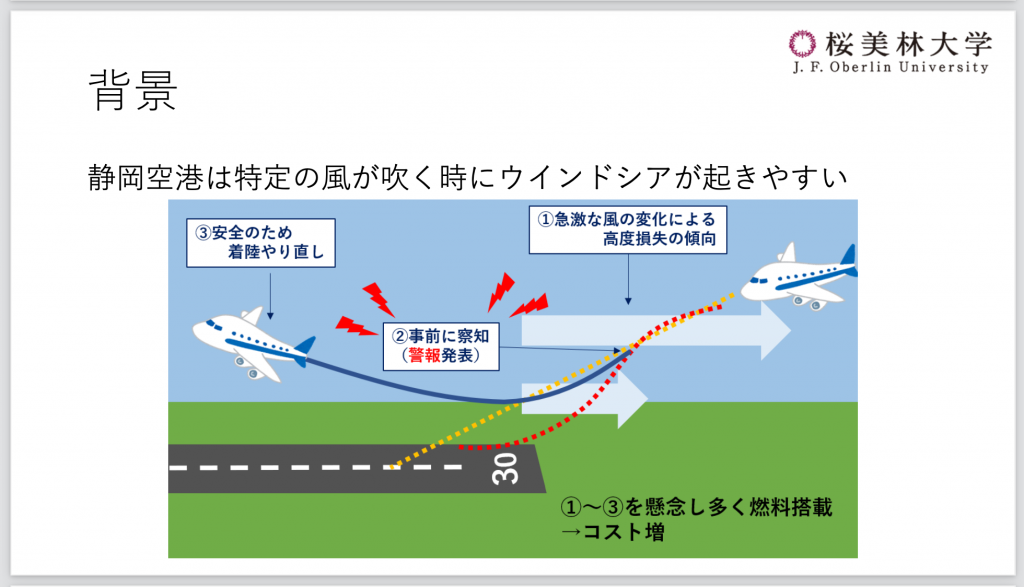
It has been reported that when “certain winds” blow at Shizuoka Airport, there are many cases of re-landings due to sudden wind changes at low altitude just before landing on runway 30.
As shown in the figure below, when an airplane lands, it usually lands by slowly descending in altitude as shown in the yellow line. Since airplanes fly by the lift force generated by the wind on the wings, if the wind changes significantly, the plane will sink or float as shown in the red line, resulting in an unstable state.
(Source: Assistant Professor Fujita, J. F. Oberlin University)
Because of the proximity of the ground just before landing, encountering windshear can cause the aircraft to descend rapidly and slam into the ground, possibly resulting in an accident in the worst case scenario.
For this reason, airplanes have a system that detects windshear in advance and sends out an alarm, and when the alarm is issued, the landing is redone to ensure safety.
Redoing the landing will increase the workload of the pilot and use more fuel. Of course, the amount of fuel to be carried on board is prepared to some extent, but the more fuel is carried on board, the heavier the airplane will be and the lower the fuel consumption. In other words, loading more fuel each time will result in extra costs.
The ideal way to avoid these situations is to know in advance when windshear will occur. This will enable measures to be taken at an early stage, such as pilot preparedness and fuel assessment. As for fuel, carrying the right amount will lead to cost savings. Therefore, in order to know windshear in advance, this study was started with the objective of investigating why it occurs.
In conducting the survey, we first interviewed pilots about their experiences. The results of the interviews revealed a trend: wind changes are particularly large just before landing on runway 30 in certain wind conditions, and at certain times of the year. Looking at the topography, we were able to hypothesize that there was a small mountain on the windward side just before landing, and that this might have an effect on wind turbulence. To verify this hypothesis, we will need to take observation data and look at it.
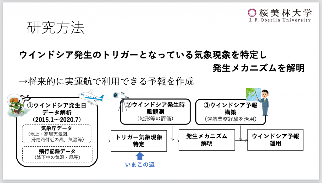
In order to understand the mechanism by which low-level wind shear occurs, we first investigated the pattern of weather phenomena in which specific winds that tend to cause wind shear blow, and then we decided to clarify how the topography affects this pattern by observing the wind during the actual occurrence of low-level wind shear.
(Source: Assistant Professor Fujita, J. F. Oberlin University)
This time, with the cooperation of the airlines, we were able to use the temperature, wind, and other data that the aircraft observes during flight. The specific research method involves first picking up the days when low-level windshear warnings are issued (i.e., when they occur), looking at the data, and checking what kind of weather conditions are being observed.
Once we have an understanding of the weather conditions that cause wind shear, we will then use Doppler lidar to observe the wind on the day of the weather condition in order to evaluate the effect of the terrain, and determine which terrain is causing the wind to be disturbed. We hope to elucidate the mechanism of low-level wind shear occurrence in this way, and to create wind shear forecasts that will be useful for actual operations.
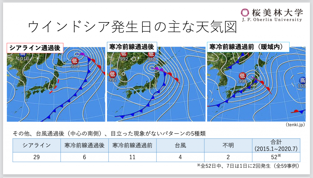
As of now (at the time of the March 2021 interview), the pressure pattern at the time of low-level windshear occurrence has become clear. In most cases, wind shear occurs after the passage of “shear lines,” which are small fronts that do not show up on weather maps, or cold fronts, and we now know that the altitude at which wind shear is encountered is different for each of these phenomena.
(Source: Assistant Professor Fujita, J. F. Oberlin University)
— Since Japan is a country of mountains and valleys, with many bumps and valleys in a small area, is it safe to assume that these phenomena can occur at any airport?
Yes, it can be said that it is more likely to occur at airports with complex surrounding terrain. For example, the easterly winds at Kagoshima and Naha airports are famous for disrupting the airflow near the ground surface.
I believe that the more experienced a pilot becomes, the more experience he or she has with these weather characteristics of different airports.
It is the weather that causes the wind, but the terrain changes it. When winds cross mountains, they can be converted into winds that bounce up and down on the leeward side of the mountains and blow in waves, which are so-called “mountain waves” (sangaku ha). The upward part of the bounce can become an updraft and generate clouds, which can be observed as the famous “hanging clouds” on Mt. If the clouds appear, the wind flow can be seen, but if they do not appear, the plane may enter into turbulent winds without knowing it, and the plane may be shaken strongly.
It would be like going down a bumpy slide. The wind is so invisible that it seems hard to imagine operating in such a place. I hope it will be put to practical use soon. Thank you very much, Mr. Fujita.
Interviewed by: Yuka Fujita, J. F. Oberlin University (J. F. Oberlin University, School of Aviation and Management)